Welcome
Thank you for your interest in this project. This virtual community meeting webpage is now closed.
We appreciate you joining us online to learn more about this study. The study is now in its final phase; the study team has completed their analysis and developed options for transit in the Highland Park area.
Click through the three activities to learn about the results of the study, find out what’s next for the study area and provide your feedback. Each activity will take 5-10 minutes to complete.
Photo courtesy of Saint Paul Public Library
How to navigate
- Click the arrow on the bottom right of your screen to go forward or the arrow on the bottom left to go backward.
- Use the navigation bar to revisit any section of the survey.
How to provide input
- Participate in the activities in this online engagement event.
- Submit a comment to the project team at any time using the "Comment" button at the top of the screen.
Accessibility information
If you would like to participate in this engagement opportunity but need reasonable accommodations, please contact our project team at info@bluelineriverviewconnection.com and we will provide assistance.
Activity 1: What We Did
Click through all four steps below to learn how we developed transit options for the study area, how we assessed them, and the outcome of our assessment
At the beginning of the study, the team evaluated the existing conditions in the study area (primarily the Highland Park neighborhood) to understand how transit was serving the community. Key takeaways include:
- Connections and access to bus rapid transit (like the A line), light rail, and bike and pedestrian facilities should be improved.
- Top destinations where people want to travel to include Highland Village, 46th St. Station, the airport, downtown Minneapolis, downtown St. Paul, Rosedale Shopping Center, and area schools.
What we learned and what we heard
- Most population and employment growth in the study area will occur at the Highland Bridge site.
- Transit supply as of August 2021 was appropriate for the study area.
- Transit ridership dropped drastically in 2020 due to the COVID-19 pandemic. Transit ridership in the area is recovering fastest on routes with frequent service.
- COVID-19 related service cuts and ongoing service cuts due to operator shortages continue to decrease transit supply in the area.
- Low frequency, poor reliability and security concerns deter transit ridership.
- Connections and access to bus rapid transit (like the A line), light rail and bike and pedestrian facilities should be improved.
- Increased density around transit corridors should be encouraged.
- Transit access to the Highland Bridge Area should be improved.
- Common transit barriers include multiple transfers, walk accessibility, low frequency of service and extreme weather conditions.
- Top destinations where people want to travel to include Highland Village, 46th St. Station, the airport, downtown Minneapolis, downtown St. Paul, Rosedale Shopping Center and area schools.
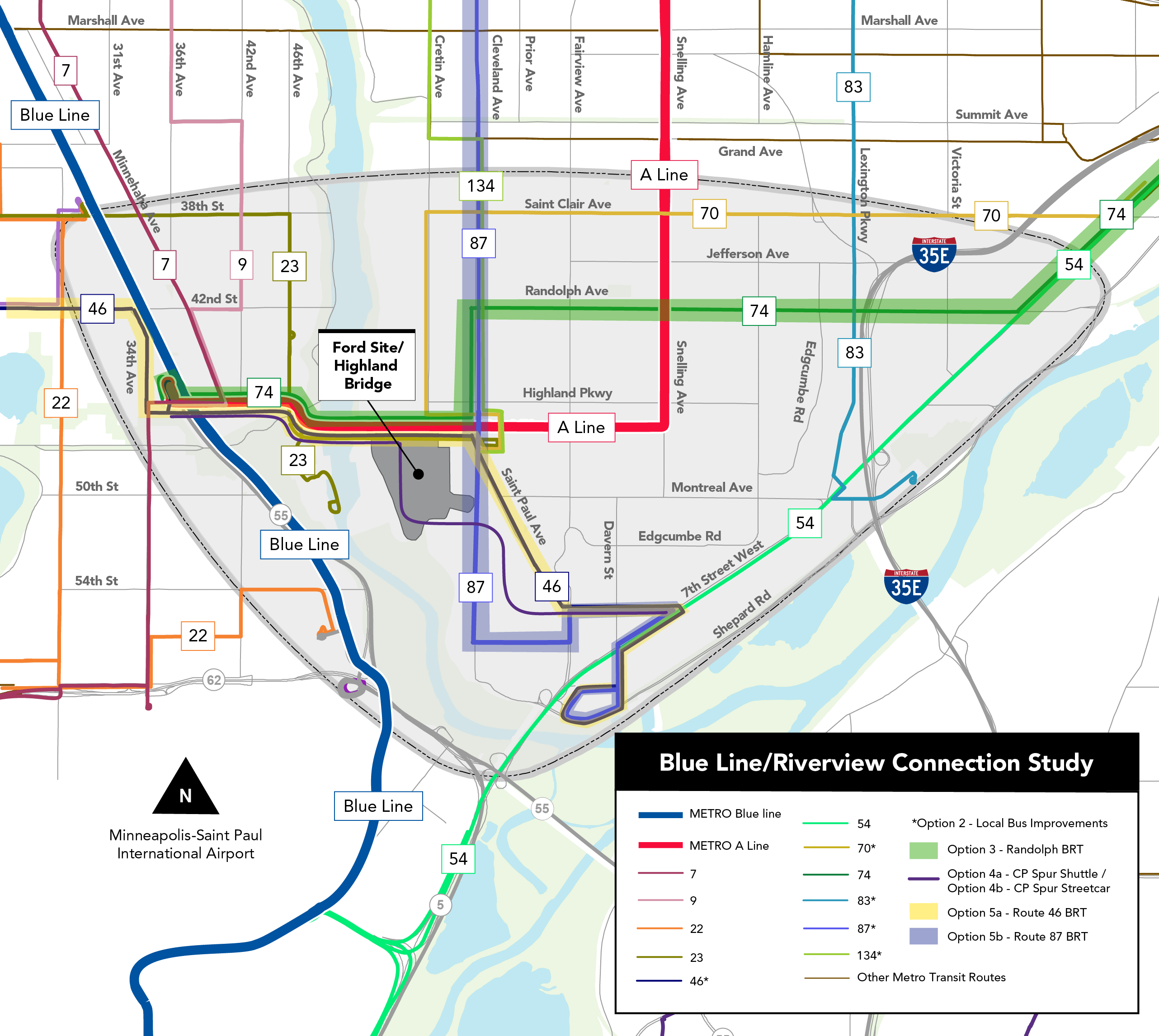
Given what we learned in Step 1, the study team developed several transit options designed to improve service levels and connectivity between routes and to destinations. In Steps 3 and 4, these options were assessed to determine how well they would fit with the future need in the study area.
“BRT” stands for Bus Rapid Transit which is a bus line that has a higher level of service. (Example: more buses are dedicated to the line, so that buses arrive more frequently)
Click the image above to enlarge.
The transit options that were assessed include:
No Build is no change to system operating characteristics, network design or supporting infrastructure. The baseline for No Build is the June 2022 Metro Transit network.
Includes improvements to pedestrian and bicycle infrastructure connections to transit, as well as transit speed and reliability improvements. Frequency and span of service improvements and re-routing of existing services are also included (baseline June 2022 network).
Upgrade Route 74 to BRT on Randolph as identified in Network Next.
Shuttlebus investment utilizing the CP spur in the southeast corner of the Highland Bridge. The service would operate as a connector service between 46th St Station and the Riverview Streetcar Corridor at West 7th. It would operate through the Highland Bridge site. This would be a feeder service for Riverview Streetcar and would not be interlined along the entire West 7th corridor.
Streetcar investment utilizing the CP spur in the southeast corner of the Highland Bridge. The service would operate as a connector service between 46th St Station and the Riverview Streetcar Corridor at West 7th. It would operate through the Highland Bridge site. This would be a feeder service for Riverview Streetcar and would not be interlined along the entire West 7th corridor.
BRT investment following the Route 46 alignment.
BRT investment following the Route 87 alignment.
Level 1 analysis screened the options for critical barriers or drawbacks at a high level and looked at factors such as alignment with future transit demand, implementation timeframe, connectivity, transit access, cost, and engineering and right-of-way constraints.
Option 1: No Build
Score:
87%
Pros:
- Provides an appropriate amount of transit service to the area.
- Implementable.
- Low engineering constraints.
- Low cost.
Cons:
- Does not enhance connectivity to destinations.
- Does not improve access to transit.
No build option
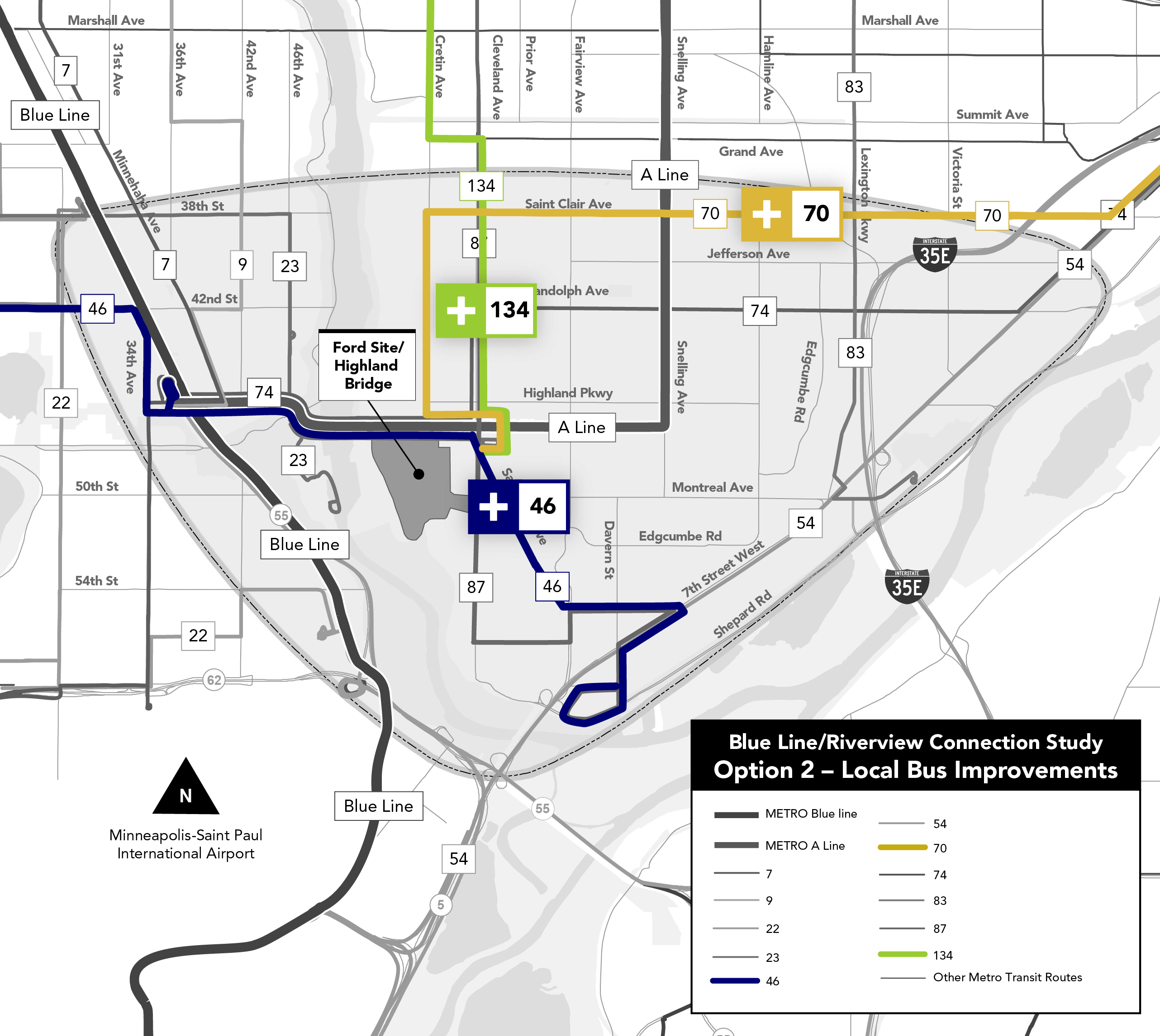
Option 2: Multimodal and Local Bus Improvements
Score:
97%
Pros:
- Provides an appropriate amount of transit service to the area.
- Implementable.
- Low engineering constraints.
- Low cost.
- Improves access to transit most out of all options.
- Moderately enhances connectivity to destinations.
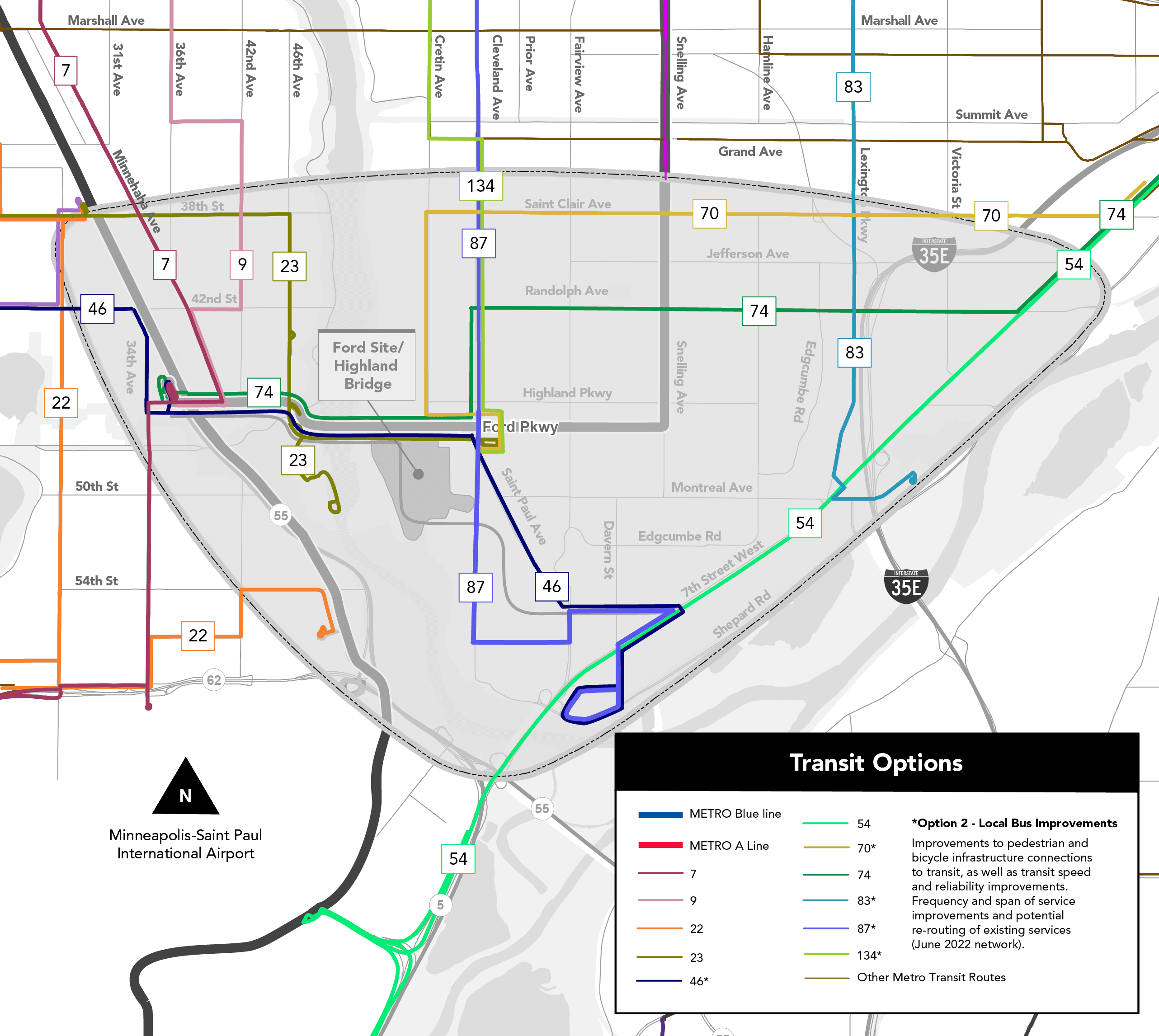
Click the image above to enlarge.
Option 3: Randolph BRT
Score:
70%
Pros:
- Could be implemented in the mid to long term timeframes (i.e. 2027-2040).
- Moderately enhances connectivity to destinations.
- Moderately improves transit access.
Cons:
- Moderately expensive.
- Moderate engineering constraints.
- Not cost effective: provides too much transit for the area and is moderately expensive.
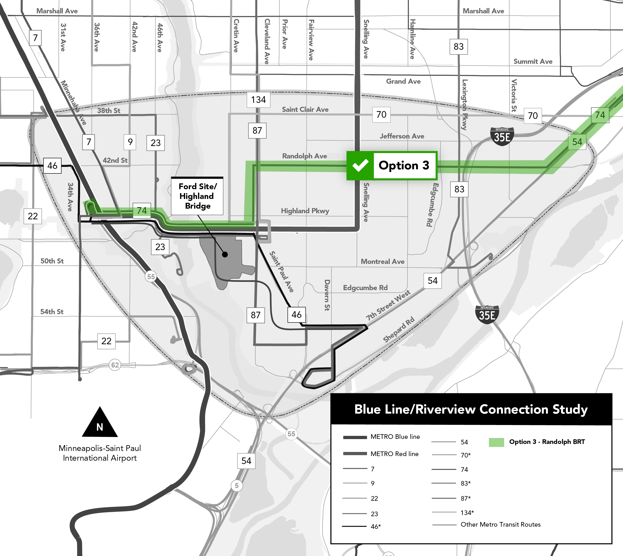
Click the image above to enlarge.
Option 4A: CP Spur Shuttle Bus
Score:
50%
Pros:
- Moderately enhances connectivity to destinations.
Cons:
- High cost.
- High engineering constraints.
- Not cost effective: provides too much transit for the area and has high cost.
Option not advanced to Level 2 analysis due to poor overall score.
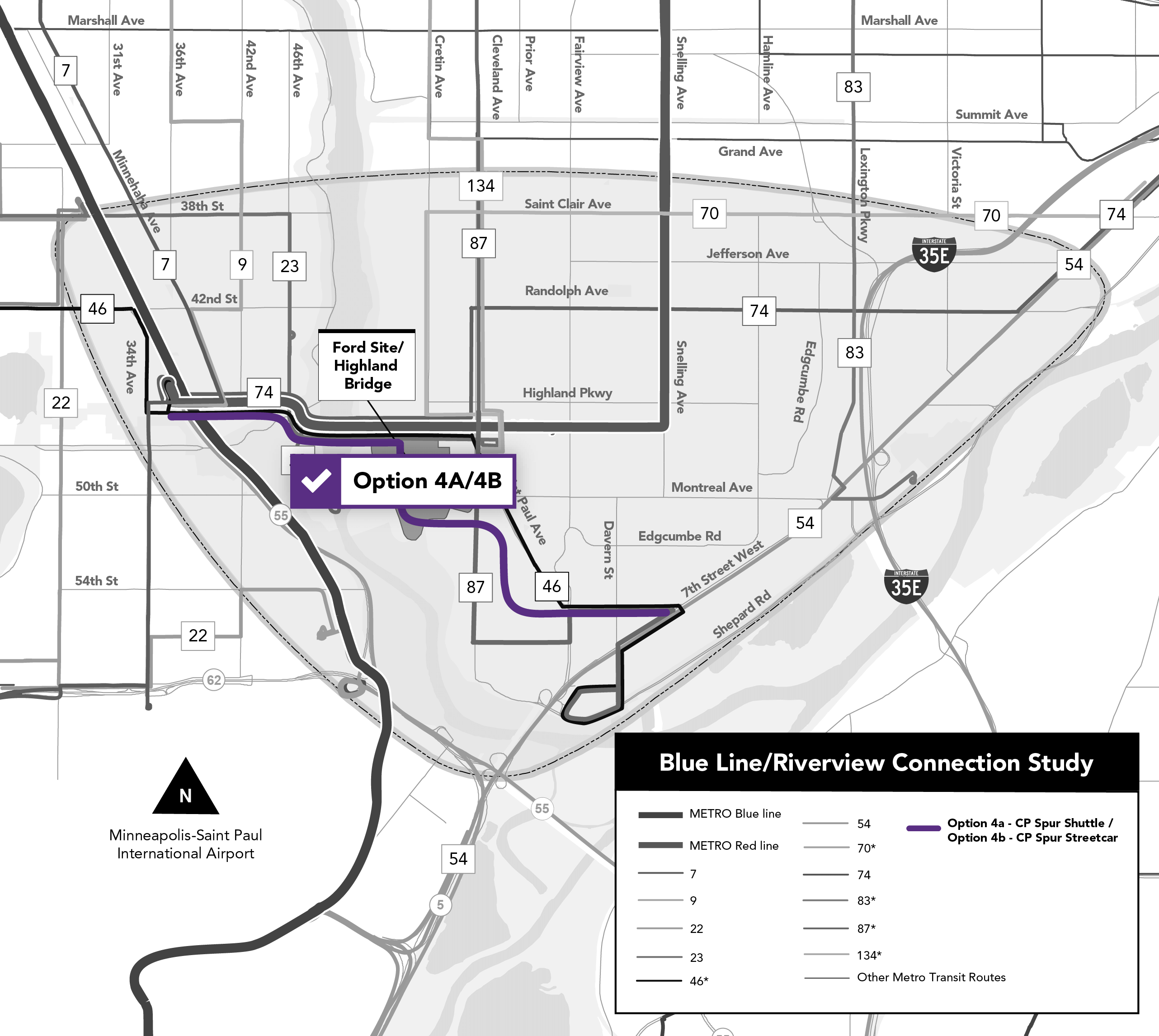
Click the image above to enlarge.
Option 4B: CP Spur Streetcar
Score:
40%
Pros:
- Moderately enhances connectivity to destinations.
Cons:
- High cost.
- High engineering constraints.
- Not cost effective: provides too much transit for the area and has high cost.
Option not advanced to Level 2 analysis due to poor overall score.
Click the image above to enlarge.
Option 5A: Route 46 BRT
Score:
63%
Pros:
- Implementable in the long term.
- Moderately enhances connectivity to destinations.
- Moderately improves transit access.
Cons:
- Not implementable in the short term.
- Moderate engineering constraints.
- Not cost effective: provides too much transit for the area and is moderately expensive.
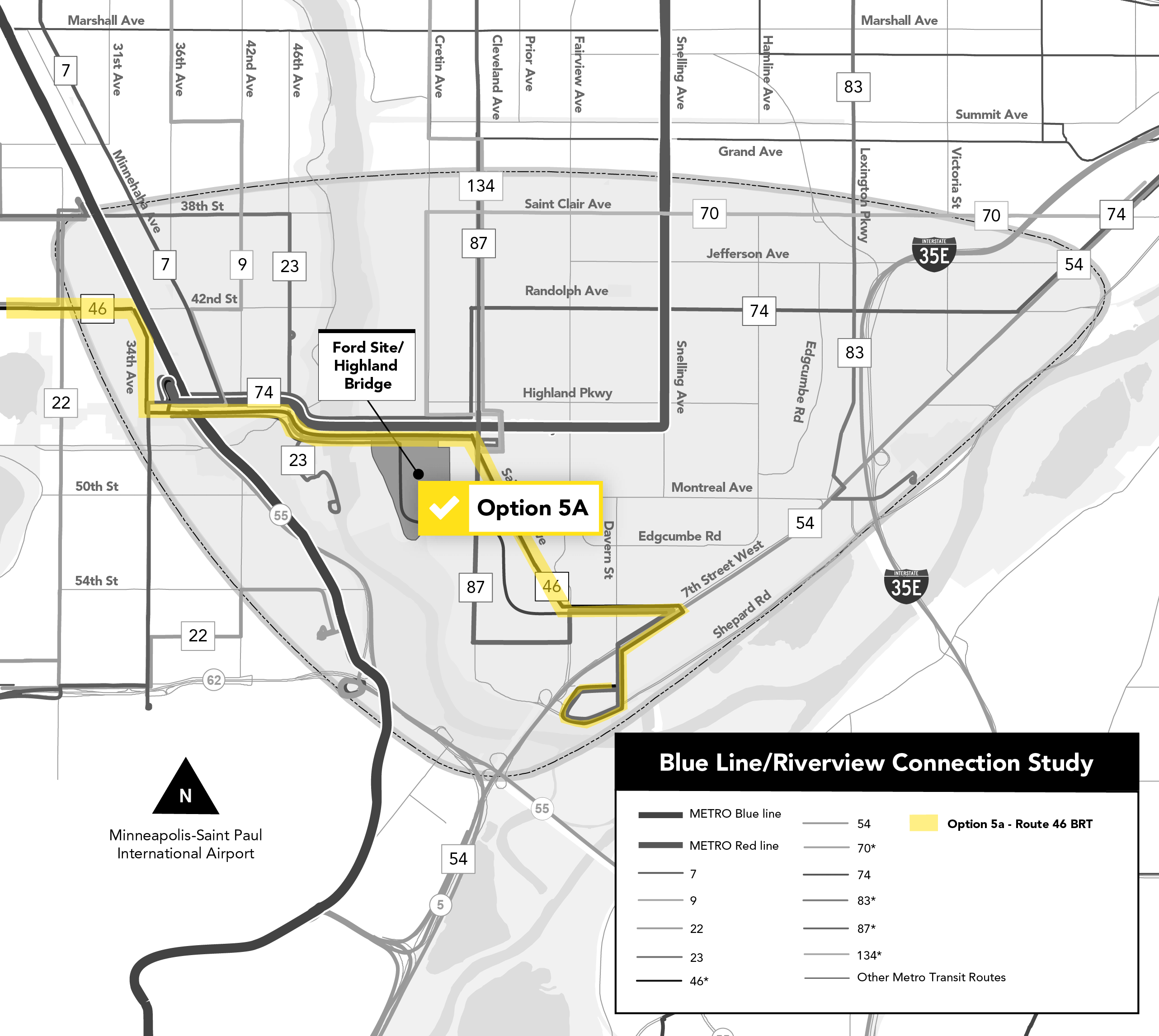
Click the image above to enlarge.
Option 5B: Route 87 BRT
Score:
60%
Pros:
- Implementable in the long term.
- Moderately enhances connectivity to destinations.
- Moderately improves transit access.
Cons:
- Moderate engineering constraints.
- Not cost effective: provides too much transit for the area and is moderately expensive.
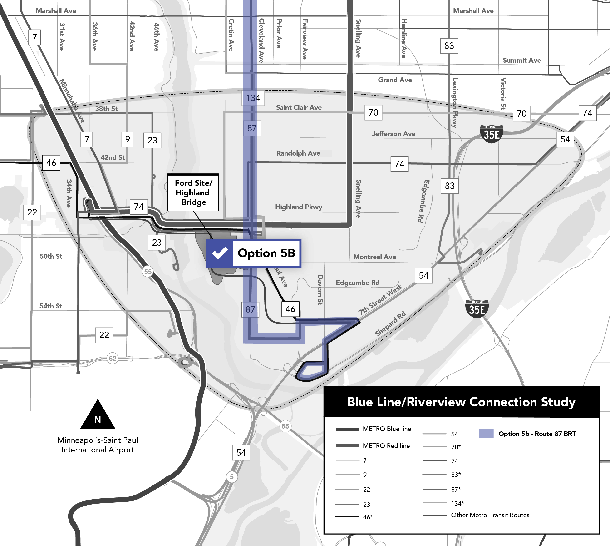
Click the image above to enlarge.
Level 1 Results Summary
Options 4a: CP Spur Shuttle Bus and 4b: CP Spur Streetcar were not advanced to the Level 2 analysis due to their low score performance (≤50% total points). These options would be more expensive, have more engineering constraints, and would provide an over supply of transit for the area, ultimately making them cost-inefficient options.
Level 2 analysis looked at the transit options that were not eliminated in Level 1 in further detail.
The goal of Level 2 analysis was to find the “right size” transit solution for the study area.
Option 1: No Build
Score:
67%
Pros:
- Low capital and operating costs.
- Aligns with future employment and population growth in the study area.
- Serves those who are most likely to depend on transit well.
Cons:
- Does not improve transit accessibility or reliability.
- Does not improve connections to services or destinations.
No build option
Option 2: Multimodal and Local Bus Improvements
Score:
88%
Pros:
- Low to moderate capital and operating costs.
- Aligns with future employment and population growth in the study area.
- Serves those who are most likely to depend on transit well.
- Improves connectivity and reliability.
- Aligns with future transit demand.
Cons:
- Walk accessibility to high-frequency transit does not improve.
Click the image above to enlarge.
Option 3: Randolph BRT
Score:
72%
Pros:
- Improves connectivity and reliability.
- Aligns with future transit demand moderately well.
- Improves walk accessibility to the high frequency network.
Cons:
- Serves those who are most likely to depend on transit poorly to moderately.
- High capital cost.
Click the image above to enlarge.
Option 5A: Route 46 BRT
Score:
65%
Pros:
- Improves connectivity to the high-frequency network.
- Aligns with transit supportive land uses.
- Improves travel speed and frequency.
Cons:
- High capital and operating costs.
- Does not align with future population and employment.
- Serves those who are most likely to depend on transit poorly to moderately.
Click the image above to enlarge.
Option 5B: Route 87 BRT
Score:
60%
Pros:
- Improves connectivity to the high-frequency network.
- Improves travel speed and frequency.
Cons:
- High capital and operating costs.
- Does not align with future population and employment.
- Serves those who are most likely to depend on transit poorly.
Click the image above to enlarge.
Level 2 Results Summary
The analysis the Study Team completed shows that Option 2 – Local Bus Improvements is the best option for the study area through 2040. The benefits to the study area from Option 2 are:
- 20.6% increase in jobs within a 45-minute transit commute.
- Estimated 200,000 vehicle mile travel (VMT) reduction annually (long term).
- 13% increase in population within a 5-minute walk to a bus stop.
- New or improved connections to 9 neighborhood nodes.
- Low capital cost per mile for bus stop improvements and transit signal upgrades.
- Improved connections to the high frequency network (HFN).
- Best option for serving populations likely to rely on transit (BIPOC, cost-burdened renters, elderly (over 65), youths (under 18), zero auto households and pop with disabilities).
Activity 2: What This Means and What’s Next
What would Option 2 – Local Bus Improvements potentially look like?
Note: the baseline network used for the study is June 2022, prior to additional service reductions to Route 46.
Map 1: Bringing service back
- Route 70 and Route 134 – re-introduce service.
- Route 46 – re-introduce service to the study area and bring back weekend service.
Click the image above to enlarge.
Map 2: Increased service levels
- Route 46 – re-introduce 20 minute weekday frequency to the study area.
- Route 46 – re-introduce 30 minute weekend frequency to the study area.
- Route 87 – increase to 20 minute all-day weekday frequency.
- Route 87 – increase to 20 minute all-day weekend frequency.
- A Line – increase to 10 minute weekday frequency.
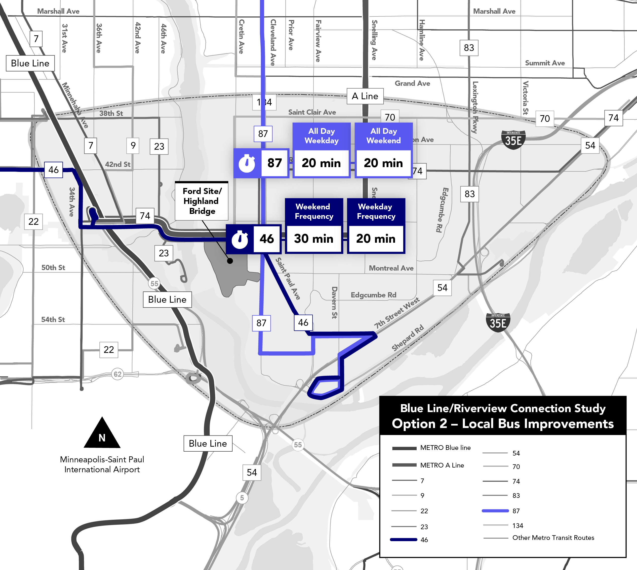
Click the image above to enlarge.
Map 3: Other improvements
- Route 83 – Reroute to serve the southern portion of Lexington Pkwy.
- Route 46 – Extend to terminate at Davern/Norfolk.
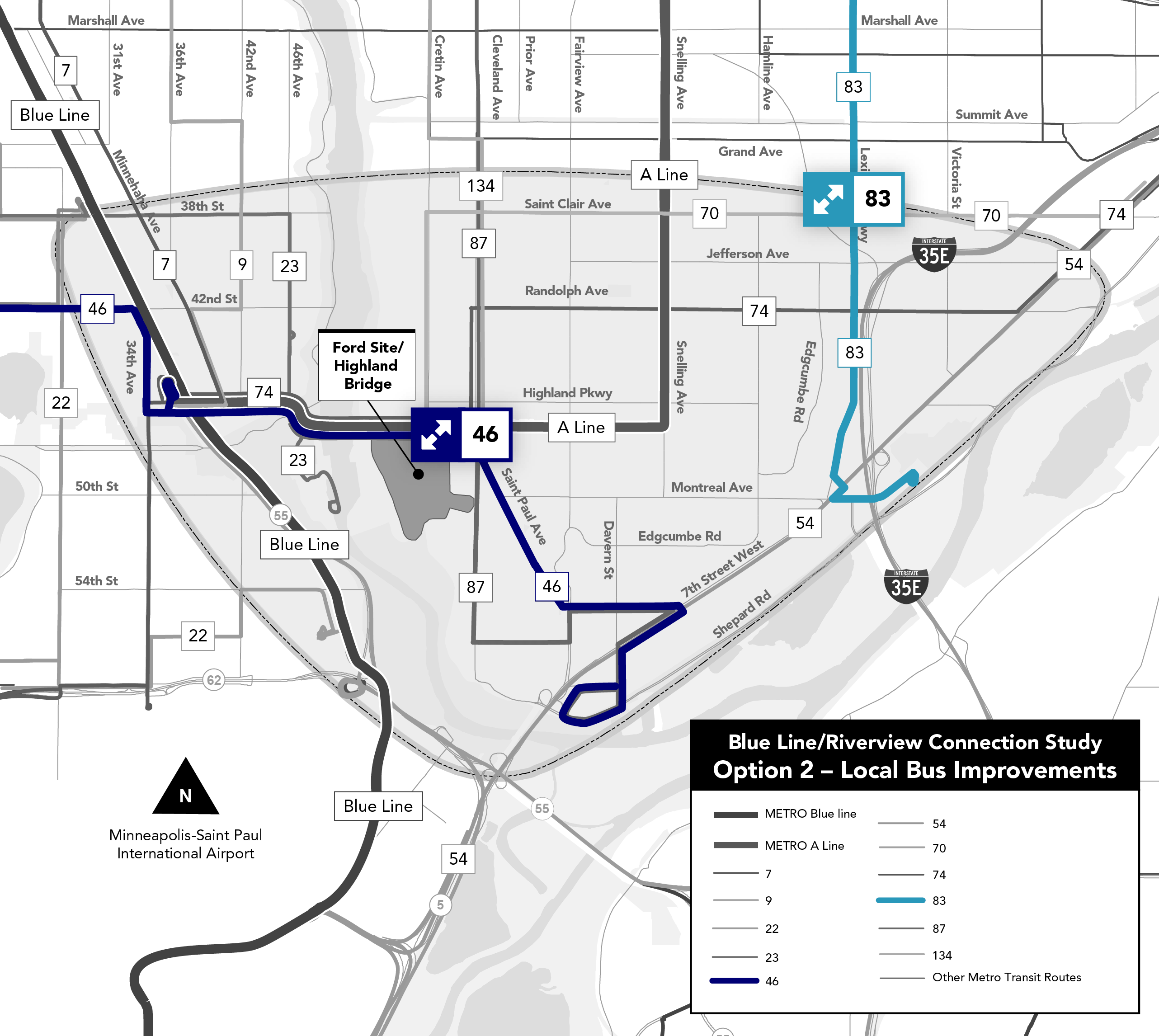
Click the image above to enlarge.
What's next?
- Metro Transit is undertaking a study called Network Now, which evaluates the entire Metro Transit bus network. The service improvements in Option 2 will be handed to Metro Transit for consideration for further analysis and prioritization as appropriate in the Network Now planning process.
- Sidewalk and bike lane improvements will need to be evaluated in detail by the City of St. Paul.